Frequently Asked Questions
about Land Surveying, Boundary and Mapping services.
about Land Surveying, Boundary and Mapping services.
Since a person may require the services of a Professional Land Surveyor only once during their lifetime, this brochure has been prepared to answer a few
commonly asked questions to assist in the selection of a Land Surveyor.
In general, a survey should be made before purchasing real property, when dividing any parcel of land for sale (in conformance with state laws and local
ordinances), and prior to the construction of any improvements on property in
which you have an interest. The services of a Land Surveyor today will
cost less in time, worry, and money than the cost of moving improvements or
defending a lawsuit later!
Q & A: WHAT WILL A LAND SURVEYOR DO FOR ME?
Question
Will a Land Surveyor tell me what I own?
No. It is your responsibility to furnish the Surveyor with a legal description, current title report, or policy concerning the parcel that you want surveyed. The Surveyor will then locate the property on the ground, and provide you with a record of survey map showing
the results of the survey.
Question
Will I be shown if there are any encroachments on the property?
Yes, if you instruct the Land Surveyor to show encroachments in the area of concern to you.
Question
Will I be shown if there are any easements on my property?
Yes, if you instruct the Surveyor to do so, and provide a current title report or title policy to use for this purpose. The Surveyor will supply a map, plat, or exhibit showing this information.
Question
How will I be shown what has been surveyed?
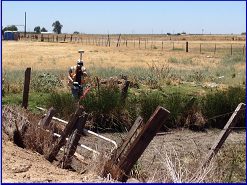
Corners of the property will be marked with stakes, pipes, or other such monuments with the Professional Land Surveyor's license number indicated thereon. The corners on the parcel will be pointed out to you, if requested. A record of survey or corner record will be filed when these monuments are set, indicating dimensions of property lines, monuments, and other relative data as required by the Land Surveyors Act, the client, or others.
Question
Why are there conflicting boundary and easement lines?
It is often true that boundary disputes and overlaps are a result of legal descriptions which were originally written and recorded without the benefit of the services of a Professional Land Surveyor. It is important to have these lines properly described and surveyed, if necessary, when property or easement lines are created or changed.
Question
Will a Land Surveyor tell me what I own?
No. It is your responsibility to furnish the Surveyor with a legal description, current title report, or policy concerning the parcel that you want surveyed. The Surveyor will then locate the property on the ground, and provide you with a record of survey map showing
the results of the survey.
Question
Will I be shown if there are any encroachments on the property?
Yes, if you instruct the Land Surveyor to show encroachments in the area of concern to you.
Question
Will I be shown if there are any easements on my property?
Yes, if you instruct the Surveyor to do so, and provide a current title report or title policy to use for this purpose. The Surveyor will supply a map, plat, or exhibit showing this information.
Question
How will I be shown what has been surveyed?
Corners of the property will be marked with stakes, pipes, or other such monuments with the Professional Land Surveyor's license number indicated thereon. The corners on the parcel will be pointed out to you, if requested. A record of survey or corner record will be filed when these monuments are set, indicating dimensions of property lines, monuments, and other relative data as required by the Land Surveyors Act, the client, or others.
Question
Why are there conflicting boundary and easement lines?
It is often true that boundary disputes and overlaps are a result of legal descriptions which were originally written and recorded without the benefit of the services of a Professional Land Surveyor. It is important to have these lines properly described and surveyed, if necessary, when property or easement lines are created or changed.
HOW MUCH WILL A SURVEY COST?
The cost for most land surveying work is determined, based on the following variables:
Record Search
This varies by (a) the number of parcels involved; and (b) the
number of past transactions. (This necessary step is complicated by the casual manner in which land transactions have been handled in the past, resulting in many vague, incomplete, and often contradictory legal descriptions and land records).
Size and Shape of Property
An irregularly shaped parcel has more corners to monument
and a longer boundary than a rectangular parcel containing
the same area.
Sectionalized Survey Work
This could require the survey of the entire section (640 acres +) in which the land being surveyed lies, regardless of the area of the parcel. In some cases, a survey of more than one section is required, depending on the location of the parcel in question in relation to the sections shown on the government plat.
Terrain & Vegetation
A level parcel of land is easier to survey than a mountainous parcel. Interference with lines of sight and accessibility complicate field work.
Amount of Existing Evidence on the Property
Existing evidence such as iron, wood, or stone monuments, old fences, and occupation lines, witness trees, etc., aid the
Surveyor. Their absence may compound difficulties involved in retracing boundaries.
Local Knowledge of Property
Someone pointing out accepted occupation lines and
monumentation is a considerable aid to the Surveyor.
Abutter Difficulties
When neighbors are cooperative, an otherwise difficult or
impossible boundary line location may be established by
boundary line agreement.
Time of Year
In the summer, foliage may present problems making survey
measurements difficult. In winter, weather may slow travel to and
onsite, and sometimes conceal field evidence.
Title Company & Public Agency Requirements
Title companies may require considerably more documentation
than is normally required by the average land owner.
Record of Survey or Corner Record
This map or record is often required by state law, to protect the
general public, if matters addressed by the Land Surveyors Act are
encountered while surveying your property. This will cause the
mapping costs to increase, and requires the payment of checking
and recording fees.
The above information was published in the brochure "How to Consult a Land Surveyor" published by the
CALIFORNIA LAND SURVEYORS ASSOCIATION
P.O. Box 9098
Santa Rosa, CA 95405-9990
Telephone: (707) 578-6016
email: clsa@ca-surveyors.org
Web: http://www.californiasurveyors.org
The California Land Surveyors Association is dedicated to promoting the highest possible standards of professional practices in the public's interest.